Recent Posts

Recent Comments

Ajinkyatara

Posted by VISHAL On 1:35 AM 0 comments
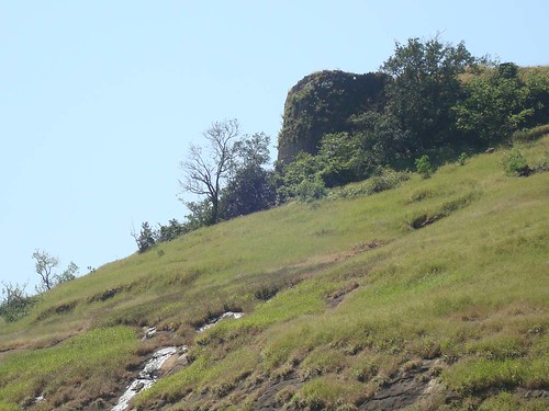
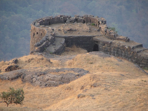
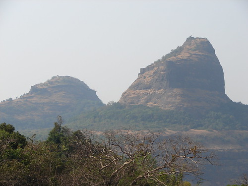
Ajinkyatara is a fort on one of the 7 mountains surrounding the city of Satara in the Sahyadri Mountains of Maharashtra. This fort has been the place where several pivotal moment in Maratha history took place.


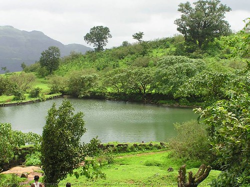
The fort is located at Ajinkyatara Mountain, which is 3,300 feet high. As the fort is in the higher altitude, visitors can enjoy a magnificent view of the entire Satara city. There are number of water tanks inside the fort for storing water. So, there is no scarcity of water even as the fort is in the higher place


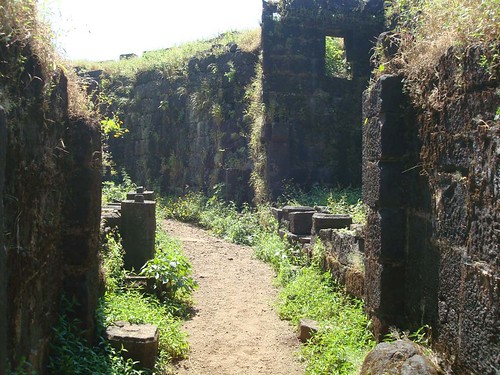
In 1708, Shahu Maharaj won Ajinkyatara, remained with the Marathas till 1818. The Ajinkyatara fort is a major historic place of Maharashtra, and was very vital as one could keep watch of the entire South Maharashtra.

Ways To Reach :

      Satara is well connected by rail and road with Pune. Take any bus from Satara station, which goes via ‘Adaalat Wada’ and alight at Adaalat Wada. Satara to Rajwada bus service is also available. Every 10 minutes a bus plies from Satara to Rajwada. The distance between the Adaalat Wada and Rajwada is of 10 minutes. From Adaalat Wada, a proper way leads us to the main entrance. All the ways towards the fort take approximately one hour to reach.


Read More......

Kenjalgad

Posted by VISHAL On 4:03 AM 2 comments

Kenjalgad or Ghera Khelanja Fort, (Wai Taluka) 4,269 feet above sea level, is situated on the Mandhardev spur of the Mahadev range eleven miles north-west of Wai. It is a flat-topped hill of an irregular oval shape, about 250 yards long and one hundred yards wide at the extremes, looking remarkably strong both from a far and near. But on ascending it is found to be commanded by the Yeruli Asre and Doicivadi plateaus about two miles to the east which are easily ascended from the Wai side, and the Jambli hills about a mile to the west.


The fort forms a village in itself but has to be ascended from the villages of Asre or Khavli which lie at its foot on the Wai side. The ascent is by about two miles of a very steep climb or the Asre-Titeghar bridle path can be followed for two miles and then a tolerably easy path leads due west from the pass another mile on to the fort. The fort is a black scarp rising vertically from the main ridge which is hogbacked.

Map :

Getting there :

Pune > Go to TITEGHAR or KORLE or AMBAVDE > The route leads up to MACHI (5 Kms) where a good shelter is available.

Go with Trek Group :TrekDi Trek Group

Check out the details here

SNAPSHOTS :


Kenjalgad Front View


Read More......

Pratapgad

Posted by VISHAL On 12:19 AM 5 comments

Pratapgad is a large fort located in Satara district, in the state of Maharashtra in India. Significant as the site of the Battle of Pratapgad, the fort is now a popular tourist destination.


Pratapgad Fort is a mountain fort built by Chatrapati Shivaji Maharaj. The fort is at a distance of 24 km from the hill station of Mahabaleshwar. The fort holds a sturdy view of coastal Konkan. The Bhavani Temple and Afzal Khan's tomb are other places of interest.


http://upload.wikimedia.org/wikipedia/en/thumb/b/ba/Shivaji_Maharajs_Statue_on_Pratapgad.JPG/800px-Shivaji_Maharajs_Statue_on_Pratapgad.JPG


Pratapgad consists of two forts - an upper fort built on the top of the hill and a lower fort immediately below on the south and the east. Surrounding areas can be easily taken guard from the fort on almost all the sides. The southern side is rocky while the eastern side has a strong outwork ending in the Afzal Buruj.


The famous minister More Tirmal Pingale on the command of Shivaji Maharaj to control the rebellious satraps of the surrounding Javali Basin built Pratapgad Fort in 1656. It is believed that Chatrapati Shivaji Maharaja was blessed with a shining sword at the temple of Goddess Bhavani here.


http://upload.wikimedia.org/wikipedia/en/thumb/a/a8/Pratapgad.jpg/500px-Pratapgad.jpg

The historic battle between Chatrapati Shivaji and Afzal Khan, the commander of the Bijapur Sultanate fought here. Bhavani Temple and Afzal Khan's Tomb are major attractions where are situated near the fort.
NEARBY ATTRACTIONS
Bhavani Temple
Bhavani temple by Sunil Shinde.
The Bhavani temple was built by Shivaji Maharaj in 1661, because he was unable to visit the famous temple of Bhavani at Tuljapur due to torrential rains. The temple is on the eastern side of the lower fort. It consists of a hall and a shrine. The hall has wooden pillars and the shrine is made of black stone. The roof of the temple is flat inside, outside is a leaden cover put by Maharaja Pratap Singh of Satara, also there is a small spire or 'Shikhar' over the shrine.

Afzal khan's Tomb
The tomb where Afzal Khan's head was buried beneath the tower bears his name, Afzal Buruj. A Dargah of Afzal Khan is constructed away from the fort to the southeast of the Afzal Buruj, where an Urs (fair) is held annually in the month of January or February.
Getting there:


By Air : Pune is the nearest airport, 120-km away.
By Train : Satara Road is the closest railway station, but Pune / Mumbai is the normal departure point for Mahabaleshwar.
By Road : State transport buses run from Pune and Mumbai. There are also MTDC / private luxury buses, that plies daily in either direction between Mumbai and Mahabaleshwar.


MORE SNAPSHOTS >


Clouds on Pratapgad


Afzal Buruj


Small Canons and Guns


Small Canons and Guns by Ankur P.


Monkey at Fort Pratapgad


DSCN2359 by Mac74.


DSCN2317 by Mac74.


Cannon at at Fort Pratapgad


DSCN2304 by Mac74.


http://farm4.static.flickr.com/3281/2338601554_cf4f8fa35a.jpg?v=0


http://farm1.static.flickr.com/246/524668119_f7e8a94b29.jpg?v=0


http://farm4.static.flickr.com/3179/2569599260_119a1cc689.jpg?v=0


http://farm3.static.flickr.com/2350/2338939379_199229c9b4.jpg?v=0


http://farm4.static.flickr.com/3025/2338905767_6f9c3b025b.jpg?v=0


Read More......

Rajmachi Fort

Posted by VISHAL On 8:53 AM 4 comments
Rajmachi Fort is one of the most popular tourist sites in Khandala. It is situated about 20 kilometers from Lonavala. It is located mid-way between Khandala and Lonavala. The fort can be reached through Tungarli Lake: this trek is popular among the beginners. Tourists willing to reach Rajmachi fort in Khandala can avail the local transport from Pune.


Rajmachi Fort is famous for trekking. The beautiful place is has exotic natural locations as well as it is a historic site. Rajmachi can be reached via the town of Lonavla along the Khandala plateau. Lonavla is an important train station on the Indian rail network. It is most convenient to start the trekking from the morning itself at around 11am.

http://farm4.static.flickr.com/3167/2948043562_97c98be1e3.jpg?v=0

Rajmachi consists of two beautiful peaks namely 'Shrivardhan' and 'Manaranjan'. Rajmachi is very famous fort near twin hill stations in Maharashtra - Lonavala and Khanadala. Rajmachi fort is nearby 18/20 Kms from Lonavala but a nice way to reach the fort is from Tungarli Lake. This trek is very good for the beginners.

Rajmachi Pond surrounded by green hills

http://farm1.static.flickr.com/13/23214936_30b83b59b3.jpg?v=0

Shrivardhan and Manaranjan can also be considered as two separate forts. There is one small platue in between them. A temple of 'Bhairoba' is very beautiful. Shrivardhan is 'Bale killa' of Rajmachi. It is almost 3000 feet high. But it was mainly built to keep watch on Konkan area. The other - Manaranjan is 2700 feet high. Manaranjan consists of strong walls, 3 doors and many water tanks. One can see Ulhas river, Dukes Nose (Nagphani), Karnala ,Matheran, Mahuli and Bhimashankar etc. The old caves of 'Kondhavi' on Rajmachi fort are worth to see. The way to fort is long but truly with a good view. One can enjoy a nice forest, Tungarli lake and many waterfalls as well. Truly, Rajmachi is one of the good places to visit around Pune. And the trekkers especially the beginners enjoy the way to fort.

Map and Direction

http://www.holidayiq.com/maps/destinations/Rajmachi-Map.jpg

More Snapshots >>

http://farm4.static.flickr.com/3039/2947179717_46aab5331a.jpg?v=0


http://farm4.static.flickr.com/3153/2948023986_9b3a70308d.jpg?v=0


Waterfall enroute Rajmachi


http://farm3.static.flickr.com/2058/2060458100_fb42c47d57.jpg?v=0

http://farm1.static.flickr.com/66/186228901_b5dfdd99cf.jpg?v=0


Rajmachi fort inner walls


http://farm1.static.flickr.com/45/135254060_ac5f7b03d6.jpg?v=0


Buruj, Shrivardhan, Rajmachi


http://farm2.static.flickr.com/1362/685454130_a13883e1d5.jpg?v=0

Rajmachi Shrivardhan and Manoranjan forts

http://farm2.static.flickr.com/1408/691941745_3039cf3e34.jpg?v=0

http://farm4.static.flickr.com/3188/2344367315_258050ac1b.jpg?v=0

http://lh4.ggpht.com/moder8or/RskXA0Rbd5I/AAAAAAAAB4o/iLJDemY0rzY/s512/P8180078.JPG

http://farm4.static.flickr.com/3153/2948023986_9b3a70308d.jpg?v=0

Read More......
Copyright 2009 - Trek FORTS Designed by Gaganpreet Singh